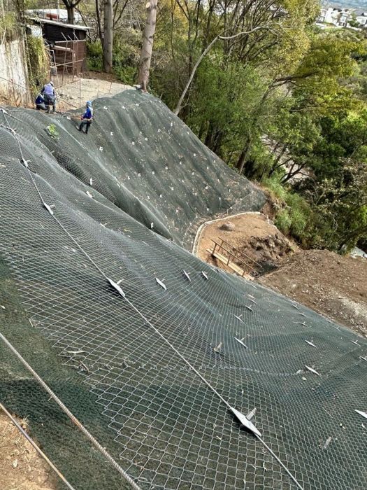
The Site 3 slope at the CNFL Anonos Facility being held by 130 soil nail anchors
Image courtesty of the University of Costa Rica (UCR), José Andrés Fitoria, and Álvaro Pérez
At a Glance
Two civil engineering students at the University of Costa Rica (UCR) built the country's first geotechnical digital twin: a live virtual replica of a 500 m² reinforced slope that calculates its Factor of Safety (FoS) in real time and projects its behavior eight hours ahead. Campbell Scientific built the instruments that enabled these students to see inside the ground.
Heroes: José Andrés Fitoria and Álvaro Pérez, University of Costa Rica (UCR)
Mission: Predict geotechnical risk on a slope before it materializes, instead of reacting to it
Site: Site 3, Anonos Facility, Compañía Nacional de Fuerza y Luz (CNFL), La Sabana, San José
Structure: ~500 m² slope held by 130 soil nail anchors, 3 to 9 m deep
Timeline: Idea in 2024; design and installation Aug 2025–Mar 2026; data collection Mar–May 2026
Instrumentation partner: Campbell Scientific (CR6 High-Capacity Data Acquisition System, SoilVue™10 TDR Soil Moisture and Temperature Profile Sensor, TDR100 Time-Domain Reflectometer, TE525MM Metric Rain Gage, plus advisory support)
Outcome: An operational digital twin with real-time FoS and an eight-hour AI forecast, the groundwork for an early warning system
The Heroes: Two Students Who Refused to Wait for the Ground to Move
José Andrés Fitoria and Álvaro Pérez set out to change how Costa Rica watches its slopes. In 2024, as candidates for the Licentiate in Civil Engineering at UCR, they chose a final graduation project far beyond a classroom exercise: build a working digital twin of a real, operating slope.
Their reasoning was simple. Most slope monitoring waits for visible signs of instability, and by then, there is a short timeframe to act. Fitoria and Pérez wanted to give those responsible for the site a different type of knowledge: the slope's present condition and where it was headed over the next eight hours.
The students took on the whole system themselves. Together they designed and installed the field instrumentation, built the data pipeline, trained the predictive model, and assembled the digital twin. Under the direction of geotechnical engineer Luis Alonso Salas Alvarado, M.Sc., their academic project grew into a functional system that exceeded everyone's expectations, including their own.
The Challenge: A Digital Twin Is Only as Good as Its Data
Fitoria and Pérez faced one obstacle that outweighed all others: without continuous, reliable data from the ground, no digital twin could exist. A predictive model with data gaps or bad readings would describe a slope that wasn't there, and the whole project would collapse with it.
The site had its challenges. Fitoria and Pérez had to:
- Keep power and an internet connection running at the slope, so measurements never stopped and data reached an external server without interruption.
- Install precision instruments inside an active construction site, coordinating material suppliers, machinery operators, and crews so every installation detail was settled before anyone touched the ground.
- Hold to a fixed academic schedule, with no room for long cycles of prototyping and debugging.
The Three Paths Considered
The students evaluated three paths forward. Designing their own sensors meant years of prototyping and no field track record. Building a new data acquisition (DAQ) system themselves carried the same risk, worsened by integrating hardware and software. The third path, pairing industrial-grade sensors with a field-proven data logger, offered validated technology, manufacturer support, and a standard they could replicate at new sites. The students chose this third path, and with it, their guide.
Path 1: In-House Sensors
- High implementation time
- No field validation
- Only team support
- High project risk
- Redesign needed for scalability
Path 2: Self-Built DAQ
- High implementation time
- No factory standards for field validation
- Only team support
- High project risk
- Reengineering needed for scalability
Path 3: Industrial Equipment and Data Logger (chosen)
- Low implementation time
- Factory calibrated with field validation proven in real projects
- Manufacturer support throughout the project
- Low project risk
- Same standard for replication at new sites
The Guide: Campbell Scientific, Maker of the Tools
Campbell Scientific's role was to provide the instruments that would enable Fitoria and Pérez to build what they imagined. Campbell Scientific supplied precision equipment built to work in the field from day one, then stood beside the builders while they shaped something new with it.
Campbell Scientific supplied the CR6 system and three of the project's field sensors, and gave timely, close advisory support throughout the installation and early data management. Fitoria and Pérez completed the instrument set with two Geokon sensors.
Here's a closer look at the equipment used:
- Centralized DAQ and management – CR6 from Campbell Scientific
- Soil moisture profile – SoilVue™10 from Campbell Scientific
- Time domain reflectometry – TDR100 from Campbell Scientific
- Precipitation – TE525MM from Campbell Scientific
- Tilt and deformation – 6350 Clinometer from Geokon
- Pore water pressure – 4500S Piezometer from Geokon
Other partners each added a piece. GEOTRAESA supported the installation and shared site studies, including soils, reinforcement drawings, and a LiDAR survey. CNFL provided access to the site and its electricity. Starlogics supplied the platform to manage and distribute the critical data.
The Build: From Field Sensors to an Eight-Hour Forecast
Fitoria and Pérez turned a slope into a live data source in eight months of design and installation, from August 2025 to March 2026. They placed the piezometer, SoilVue 10, and clinometer into the reinforced slope, wired them to the CR6, and programmed the data logger in CRBasic.
Their digital twin works in three steps:
- Field sensors measure the variables that govern stability: pore water pressure, soil moisture, deformation, and rainfall.
- Real-time data flows automatically. The CR6 consolidates each reading into a plain text file and sends it over HTTP, at a preset frequency, to an external server.
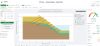
- Prediction and early warning The twin calculates the slope's FoS in real time, and an AI model projects its behavior eight hours ahead.
The Campbell Scientific equipment proved simple to configure and calibrate. Plausible data began flowing almost automatically from start-up, which let Fitoria and Pérez spend their limited time on the model instead of on troubleshooting hardware. From March to May 2026, the system collected data continuously.
The Results: Costa Rica's First Operational Geotechnical Digital Twin
Fitoria and Pérez delivered what no one in the country had before: a digital twin that showed a slope's present safety and forecasted its future. It is one of the few systems in Latin America that combines in-situ instrumentation, automated data management, and predictive AI on a real, operating stabilization structure. More specifically, this student-led project produced these results:
- A robust database. Three months of continuous, plausible measurements of pore water pressure, moisture, deformation, and precipitation are validated by the equipment's own calibration.
- A live FoS. Site managers can see the slope's stability as it stands, not as it looked at the last inspection.
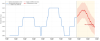
- An eight-hour forecast. A Long Short-Term Memory (LSTM) model projects the water table with a ±2·RMSE band of 0.42 cm, giving decision-makers a realistic timeframe to act before a risk materializes.
- The groundwork for early warning. The foundation of a new national standard for geotechnical monitoring was created.
José Andrés Fitoria and Álvaro Pérez remarked, "Working with Campbell Scientific was the key to obtaining the indispensable inputs for our project."
The win was a shared one. UCR, private companies, and a public utility worked toward a single goal: stronger disaster prevention and proactive risk management in Costa Rica.
What's Next: One Slope Is Only the Beginning
Fitoria and Pérez see Site 3 as a starting point, not a finish line. Their methodology is replicable and scalable, and they plan to carry it outward in three stages:
- Soil-nailed slopes: the validated success story at Site 3, Anonos Facility
- Other geotechnical works: new reinforcement types and site conditions
- Structural, hydraulic, and environmental works: expansion into new civil engineering disciplines
Each new project will call for new instruments, and the students intend to draw further on Campbell Scientific's portfolio as they go. As they put it, they want Costa Rica's first geotechnical digital twin remembered as the beginning of a collaboration, one that brings live, predictive monitoring to more critical infrastructure across the country and the region.
The case study photos were provided by the University of Costa Rica (UCR), José Andrés Fitoria, and Álvaro Pérez.